DISTANT PLACES
Travel tips for destinations far from the Hanseatic City of Bremen
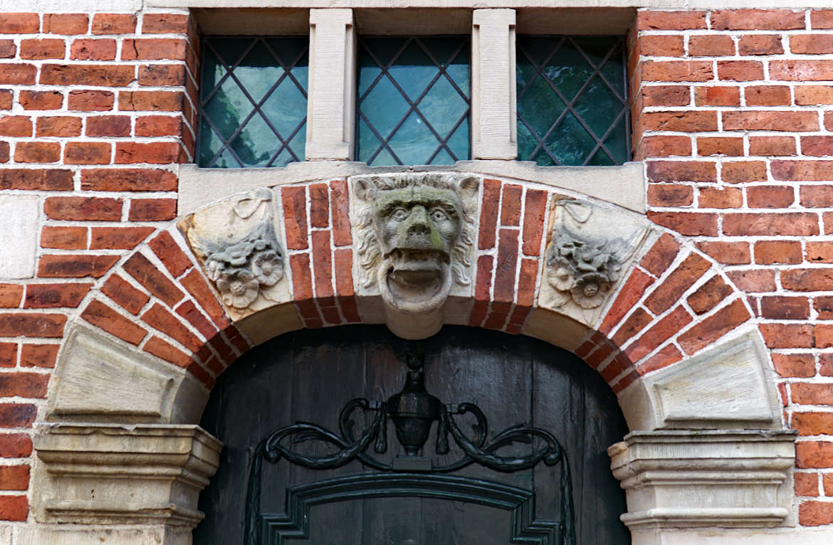
Emden in East Frisia
Where East Frisians make jokes and serious art thrives
Page 2 of 3
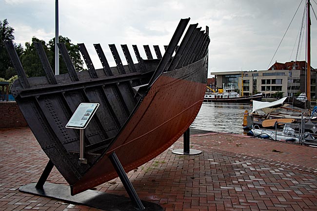
Old under water part of the Exploration Ship "Ems" (Built in 1934), Now Decommissioned and Moored on the Opposite Bank of the Inner Harbor
Today, the Ratsdelft is a museum harbor. The former sea rescue cruiser "Georg Breusing," built in Lemwerder near Bremen in 1963, has its permanent berth here along the promenade of the same name. The current museum cruiser, operated by a private association, was decommissioned by the German Maritime Search and Rescue Service (DGzRS) in 1988. Incidentally, the ship's tender is named "Engelke up de Muer." Alongside Engelchen, the name Georg Breusing is also associated with the East Frisian city. Born in Osnabrück in 1820, this man was a senior customs inspector in Emden and founded the first maritime rescue association in Germany here in 1861. The association remained regionally active but became part of the DGzRS, founded in Kiel seven years later, which today operates rescue stations along the entire German coast.
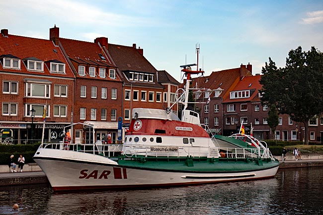
The museum cruiser "Georg Breusing" in Ratsdelft
On the way from the city gate to the museum cruiser, however, it might briefly get a bit wet from above, as water is spat down from the elevated sidewalk. Two out of three men who are always standing around here indulge in this nuisance. The two Delftspucker statues, Joke Rinne and Hinnerk de Vries, created by Hans-Christian Petersen from Esens, were donated by Emden citizens in 2018 and 2017 respectively and cast in bronze. While this is amusing for city visitors - either getting unexpectedly sprayed or watching others get wet - it actually has a historical background.
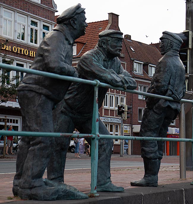
Delftspucker
Until 1898, a long wooden bench stood behind the iron railing where older men, especially after their working lives, and vagrants liked to gather. This bench disappeared with the demolition of the town hall bridge and the construction of the Delft staircase. Nevertheless, this place remained an attractive meeting spot for them; they simply stood there until World War II, leaning against the railing as they chatted. The fact that they spat into the Delft in high arcs was due to the consumption of chewing tobacco or "priem," which was popular at the time and even produced in large quantities in East Frisia. This tobacco, mixed with other substances and also containing nicotine, was held longer in the mouth and not constantly chewed. The secretions mixed with saliva were spat out as a brown liquid, just like the tobacco itself when it had turned into a thick paste. Chewing tobacco was particularly popular among sailors because fire was always a problem on ships, especially when striking a match - which wouldn't light anyway if water wasn't just under the keel but also falling from the sky and seeping into the below-deck compartments.
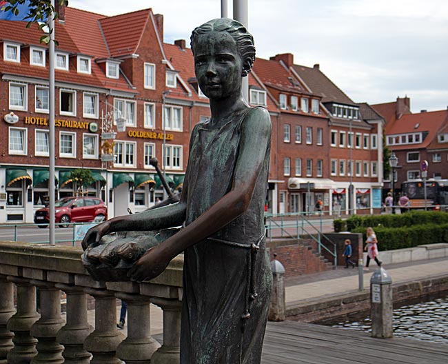
The Emden fish girl "Jantje Vis"
The aforementioned Delft Stairs are now also a popular meeting point for tourists and locals alike, as well as the starting point for the harbor tour. Since 1986, the Emden fish girl "Jantje Vis" from the workshop of Karl-Ludwig Blöke in the neighboring town of Leer has stood at the top of the stairs, donated by the Lions Club Emden. She stands barefoot, wearing only a thin, simple sleeveless dress and holding a few fish in a bowl, looking over to the Stadtgarten with its cafés. Or perhaps she is looking at the men at the Fürbringer Fountain? There, water splashes merrily around an obelisk flanked on two sides by a fisherman with his full net and a harbor worker. The stone structure dates back to 1900 and was erected on the occasion of the 25th anniversary of the term of office of then Mayor Leo Fürbringer. He was instrumental in the extensive expansion of the harbor, hence the maritime fountain motif and the honor. In any case, the girl is a frequently photographed object and just as eagerly touched, as evidenced by the shiny spots on the bronze.
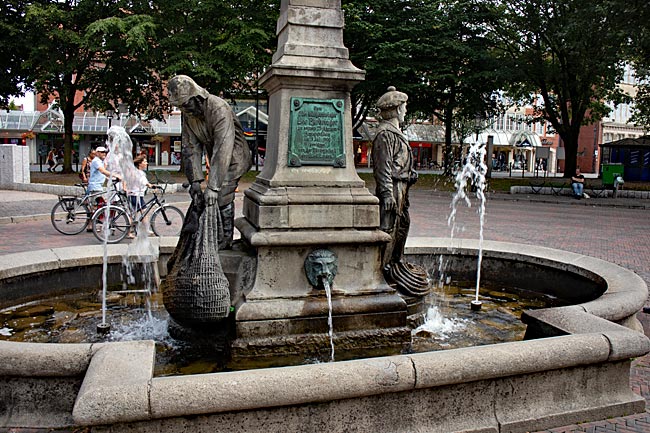
The Fürbringer Fountain in the Stadtgarten
Fish is also a topic when walking along the Georg-Breusing Promenade past the museum ship and the former lightship "Amrumbank," for then you come across the museum logger "AE 7-Stadt Emden." Since 1995, this wooden ship, originally built as a sailboat in 1908 in the Dutch town of Scheveningen, has been moored in the Ratsdelft and stands - or rather floats - as a testament to a tradition dating back to the 16th century in Emden, as well as in the nearby Netherlands. Unlike there, however, this tradition ended in Emden after about a hundred years of revival in the mid-1970s of the last century. Uneconomical practices were the death knell for many German fishing fleets - without rebirth to this day. Loggers are the special ships used for herring fishing, and it is this small schooling fish that has given the city on the Ems its aforementioned tradition.
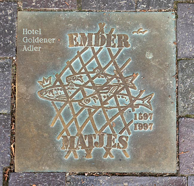
Embedded in the ground on the occasion of a 400-year-old tradition
Around 100 loggers left the harbor of the East Frisian city at the height of herring fishing, especially between June and August, to return with such large catches that the export of finished products made Emden regionally famous: Emden Matjes. However, not every herring becomes matjes, but only the comparatively mild, not yet sexually mature ones, which are pickled raw in brine according to a traditional process. As early as the 16th century, there were clear regulations in Emden for processing the fish into matjes, such as the quality of the oak barrels. The process itself had been developed by the Dutch as far back as the Middle Ages. Even in today's Hanseatic city of Bremen, Vegesack was once home to one of the largest logger fleets, but unlike in Emden, you will only find "real Dutch matjes" in the fish shops of the city, either piece by piece or even bucket by bucket. For several decades now, Emden has celebrated Matjes Days in May - naturally with Emden Matjes - and during this time, there is plenty of herring to be had around the harbor - if you like it.
Another option: what you can't get rid of, you integrate; there are many bunkers from World War II in Emden
The buildings around the inner harbor area are not particularly architecturally outstanding. Yes, people live here and Emden is not a museum. But sometimes you just don't have to look. This works especially well on a peninsula between Ratsdelft and the inner harbor after leaving the museum ships behind. Sometimes you don't need much, just a few steps with wooden seating and that's it. The hustle and bustle of the modern city is far enough away, and your gaze sweeps over the water and the shores, where, for example, there is also a camper parking area. A nice place with a cool drink when the sun goes down or something like that. Most people sitting here, whether young or old, probably have little sense of the astronomical ensemble that admittedly looks somewhat out of place on a small patch of lawn in the immediate vicinity, along with a replica of the Nebra sky disk. As early as the Bronze Age more than 4000 years ago, people looked up at the sky and tried to record their observations - impressive. For seafarers, looking at the sky in earlier times was a matter of life or death - open ocean or saving harbor.
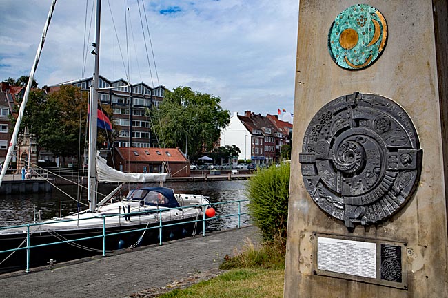
Looks complicated, it is
Those who sail not over the sea but over canals need not worry about such problems. And Emden is connected to the East Frisian hinterland via many inland waters, whether natural waterways or artificial ones. The Ems-Jade Canal between Emden and Wilhelmshaven was artificially constructed. From 1880 onwards, this connection through East Frisia was dug for eight years. Canals are nothing particularly extraordinary, but a length of 72.3 kilometers is quite impressive. Wilhelmshaven was an imperial war harbor and fleet location, but large ships did not fit through the canal even back then; the maximum ship width of just over 6 meters and less than 2 meters draft were much too small. Today, 41 bridges connect the banks, most of them movable, and six locks compensate for differences in water levels and keep the gauges stable.
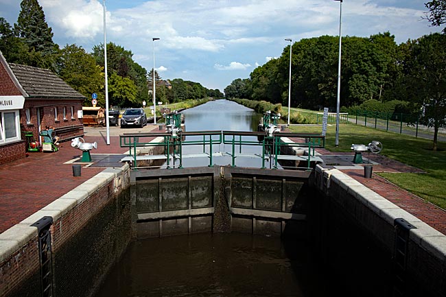
View over one of the lock chambers of the Kesselschleuse onto the Ems-Jade Canal
From Emden, the footpath and cycle path along the canal is popular with many who want to leave the central location on foot, jogging, cycling, or walking their dogs. Almost inevitably, you pass by a special structure: the Kesselschleuse. The word "kessel" (cauldron) sounds somewhat unpleasant depending on its meaning - in the cauldron, all sorts of things were once heated - laundry, food, and with cannibals ... let's leave that ... or in Stalingrad during WWII, the 6th Army was encircled and thousands died in the Russian winter. Well, nothing like that will happen in the lock's cauldron, but there is a slight feeling of being confined, even just from watching, and you can do so from almost all sides. The condition is temporary, but the procedure takes time.
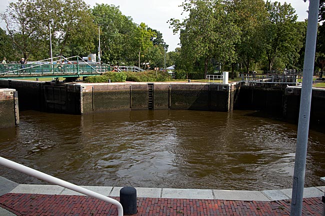
The round chamber of the Kesselschleuse with two of the four lock chambers; on the left side of the image is the Van-Ameren Bad next to the canal
Four bodies of water from four districts converge at this point, coming from all four cardinal directions: the aforementioned Ems-Jade Canal in the east, the Fehntjer-Tief in the south, the extension of the harbor in the west (Rotes Siel), and Emden's city moat in the north. The unique structure was originally built between 1886 and 1887 but was already renovated and expanded to its current size from 1911 to 1913.
Today, four smaller lock chambers lead mostly recreational boats into the 33-meter-diameter round chamber as an intermediate station. To move from one body of water to another, unlike in standard lock operations, it requires two lockings and thus time.
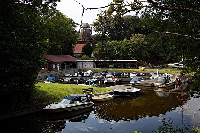
A section of the city moat with leisure boats and the windmill "De Vrouw Johanna," which was built in 1804/05 on the city wall, Emden's former defensive structure.
The Emden city moat has already been mentioned; it is a remnant of the old fortifications that once surrounded the city on the landward side in more than a semicircle. The water side was naturally protected by the Ems River flowing past the inner city at the time.
Between 1606 and 1616, Emden citizen and master builder Gerhart Evert Pilooth constructed the existing defensive structure on behalf of Count Enno II of East Frisia from the House of Cirksena. He was supported by the Dutch fortification engineer Johan van Valckenburgh, after whose plans the protective walls in Hamburg and Bremen were also built.
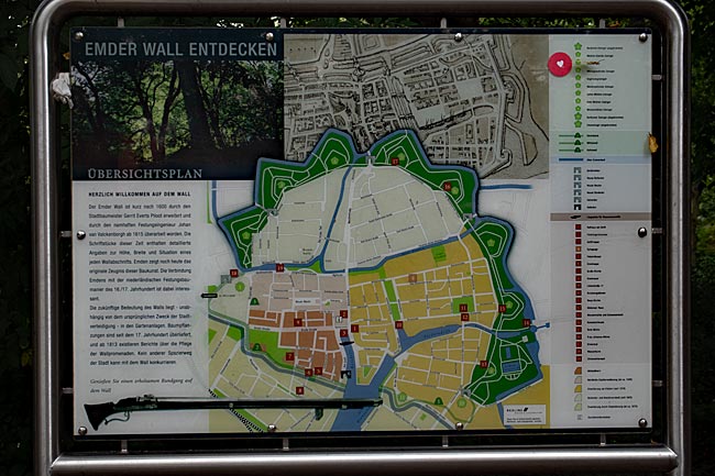
Information board at Emden Wall. Well-made boards like this one can be found throughout the city under the heading "Discovering Emden's Monuments," allowing you to delve into a part of the city's history
After completion, the facility featured 11 pentagonal bastions, known as zwingers, each at the outer tips of the zigzagging wall. From there, one had an overview without blind spots, and when the bastions were equipped with cannons, they also provided good defensive capabilities. These proved successful during the Thirty Years' War about thirty years later, as Emden was not captured. Afterward, however, the wall gradually lost its importance. Still within the same century, trees were planted there, and the entire structure was later successively transformed into a park landscape. According to an information board showing the course of the green belt, there have been "reports on the maintenance of the wall promenades" since 1813. The attractiveness of these promenades has been preserved to this day.
Map
1. Rügen by the Baltic Sea
actual page
2. Rügen by the Baltic Sea
Nordperd: hiking through the forest to the cliff
The mostly forested promontory - this is what the word Perd means in Slavic - is part of the Mönchgut Biosphere Reserve. And indeed, from the air, the area juts out like a green pointed triangle into the sea.
Along the beach to Thiessow and Klein Zicker
After a short museum visit, our path leads us through the sand of the Baltic Sea past the village of Lobbe to the end of the beach in Thiessow - a considerable distance for persistent hikers coming from Göhren, always with a salty breeze in their noses.
read more about Rügen ...
3. Rügen by the Baltic Sea
Cycling from Göhren to Reddevitzer Höft
The farther you cycle along Reddevitzer Höft, the sparser the settlements become. Where no houses or trees obstruct the view, you can see the Rügischer Bodden with Having Bay on one side and Hagensche Wiek Bay on the other. This is especially true when you reach the 33-meter-high elevation at the end of the peninsula. From the cliff, you have a wide view across the water toward Vilm Island or the village of Gager with its small harbor.
read more about Rügen ...
4. Rügen by the Baltic Sea
Seaside resort tour on foot or by bike
From the north beach in Göhren, the next seaside resort in the other direction is already within sight: Baabe. So you can simply stroll barefoot along the water or use the Amber Promenade as an equally direct route, though with a solid surface. Cyclists can also make good use of this and find it well-developed parallel to the promenade. A slightly bumpy and longer option is the combined cycling and hiking trail through the forest, connecting the two seaside resorts over 2.5 kilometers.
A bike trip form Baabe to Seedorf and to the seven megalithic tombs from the Stone Age near Lancken-Granitz
The charm of Seedorf lies primarily in its harbor: docks with moorings for many recreational boats along both shores of the inlet to Neuensiener See. Here, sailboats and motor yachts are safely anchored away from the sometimes rough seas of the Baltic Sea, yet their skippers can quickly reach it if needed.
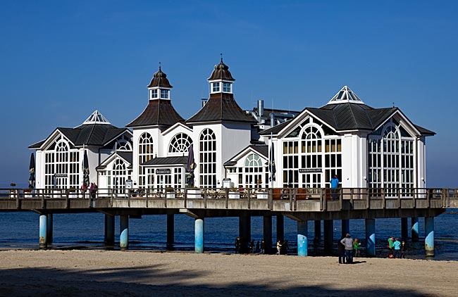
A seabridge and spa architecture in Sellin
Long before reaching Sellin along the beach, you’ll spot the impressive 394-meter-long pier, which has a turbulent history dating back to the early 20th century.But Sellin has more to offer than just the magnificent structure right on the beach. The so-called "Stairway to Heaven" leads up many steps to the high bluff, connecting the pier with Wilhelmstraße promenade.
read more about Rügen ...
5. Rügen by the Baltic Sea
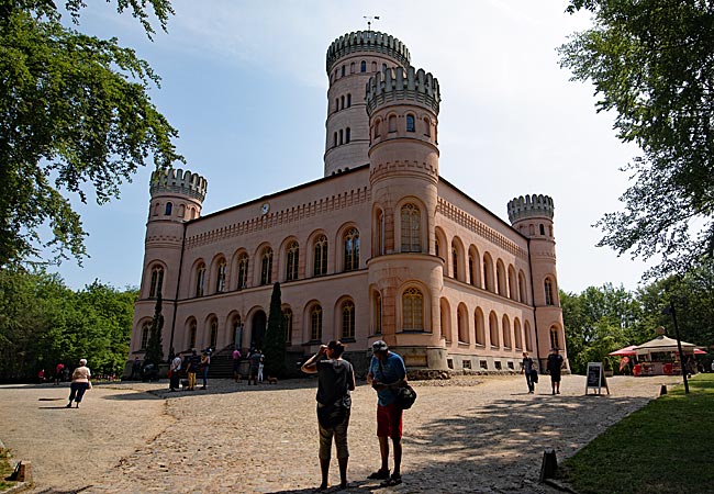
Through the forest to Jagdschloss Granitz
It's about 5 kilometers from Sellin through forest paths up to Jagdschloss Granitz. If you're on foot, you can initially take the cliff path through rough terrain at your own risk; by bike, there are additional better-developed paths. All paths eventually converge and lead well-signposted to the hunting lodge and Binz. The castle is also located along the route of the Rasender Roland, about one kilometer downhill to the station. In the other direction, it's about 3 kilometers through the forest to Binz.
Art and more in Binz, the largest seaside resort on Rügen
If you arrive as a visitor from the sea side, on the one hand, the size of the place in general and the 1890-opened Kurhaus as the unmistakably largest and most impressive building in particular catch your eye. Even in the off-season, Binz is much livelier and busier than the places in its immediate vicinity. Historical houses in the style of spa architecture can also be found here, whether directly on the beach promenade or in the shopping streets of the town. And regardless of whether you arrive by ship or by bus, you are immediately in the midst of the action.
read more about Rügen ...
6. Rügen by the Baltic Sea
From Binz to Sassnitz
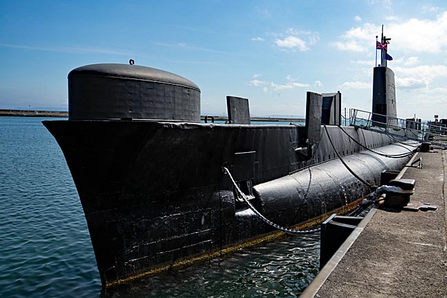
Since 2007, a 250-meter-long suspension bridge has allowed pedestrians to quickly reach the city harbor from the city center - offering a wide view of the harbor and the Baltic Sea. If you use the suspension bridge, you will immediately encounter the most unusual ship in the harbor: the H.M.S. Otus. This 90-meter-long British submarine of the Oberon class, built in 1962, has been decommissioned and is now a walkable museum.
To the chalk cliffs with the 118-meter-high Königsstuhl in Jasmund National Park
From Göhren, Sellin, Bilz, or Sassnitz, you can also book a trip to the chalk cliffs with the ships of Adler-Reederei, offering a view from below of the relics from the Cretaceous period, which began approximately 145 million years ago and ended around 66 million years ago, instead of the panoramic view from above.
read more about Rügen ...
7. Rügen by the Baltic Sea
By water to Lauterbach and Putbus
Sellin. The open Baltic Sea on one side, a lake, a bay, and a "shallow bay-like coastal water body" - the Bodden - on the other. This is where the ships of the White Fleet sail. From Lauterbach, a two-lane main road leads about two kilometers into the center of Putbus - getting lost on the green avenue is practically impossible. Thus, after the described walk, you first encounter the Circus. The model for the facility built between 1828 and ’45 was the Circus constructed a century earlier in the English spa town of Bath.
read more about Rügen ...
8. Rügen by the Baltic Sea
Travel Information
Many hopefully helpful pieces of information for the described part of Rügen. Unfortunately, not all websites are available in English yet. Nevertheless, I am sure you will have a wonderful time on Germany's largest island. Take care.
read more about Rügen ...